
TVERC data and who should use it?
TVERC data available
All of these datasets are accompanied by a metadata document which provides a full description of the information within the dataset. The metadata is sent to your local authority contact and GIS officer at the same time as the GIS dataset and should be stored in the same location so you can refer to it. We provide you with datasets for your local authority area (plus a 5km buffer for species data).
- Protected & notable species (July, November and March)
- Buffered protected species & notable (July, November and March)
- House sparrows, starlings and swifts (July, November and March). Rebranded “Birds in Buildings” with the addition of house martin nest records in March.
- Swift Hotspot Maps (provided to all partners from March)
- Local Wildlife Sites (May)
- UK Priority Habitat (NERC Act S41 Habitats of Principle Importance) (December)
- Invasive non-native species layer (July, November, January)
If you need data for a larger area, get in touch.
Who should use TVERC data?
TVERC data is most frequently used in the planning department, and by your ecologist, but it has many other uses too...
Development Control Planners: Decide who to consult, whether to ask applicants for ecological surveys, assess the impacts of a development and decide what mitigation or compensation is required. Ensure planning decisions comply with planning policy and legislation.
Policy Planners: Compare the benefits and impacts of allocating strategic sites for housing, roads, minerals, waste in different locations. Ensure plans and policies comply with planning policy and legislation.
Highways Engineers: Avoid breaching wildlife law by checking for legally protected species records before starting maintenance work (e.g. watervoles in culverts and bats in bridges). This will help prevent costly delays to maintenance work if they’re discovered once work has started.
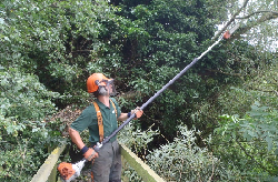
Tree / Arb. Officers: Avoid breaching wildlife law by including a check for bat roosts and nesting birds in standard risk assessments before tree works/vegetation removal. This will help prevent costly delays to maintenance work if they’re discovered once work has started.
Parks Officers: Find out what wildlife is already in the local area, and what could be… Use this information to manage parks to encourage wildlife, which will increase the mental and physical wellbeing of local people and increase community cohesion.
Landscape Officers: Advise that local, native species are used for planting schemes, perhaps even some nationally rare or scarce plants.
Ecologists / Biodiversity Officers: all of the above!


