Biodiversity Report
We offer a Biodiversity Report which packages up the data relevant for most planning, conservation, and land management needs. This report includes species records for protected, notable and invasive species, the details of the protected sites, and the locations of priority habitats within 2km of your site. The information is presented as a pdf report, with options for GIS files and webmaps to view the information in other formats. Click here to view an example of a data search report.
Local Nature Recovery Strategy Report
TVERC presents a personalised version of the full Oxfordshire and Berkshire strategies focusing on your site and surrounding 2km.
The LNRS includes areas that are already known to be important (‘areas of particular importance for biodiversity’ - APIB), key opportunity areas to target nature recovery actions (‘areas that could become particularly important for biodiversity’ - ACB), and biodiversity priorities and measures for habitat creation, enhancement, and restoration (‘potential measures’ - PM). This report collates the LNRS data and presents the information and opportunities surrounding your site to help you identify the actions available for delivery under the LNRS to benefit nature recovery and biodiversity.
The information is presented as a pdf report, with options for GIS files. Click here to view an example of a LNRS report.
Species
A standard search includes protected, notable and invasive species within the search area. The recorded period is between 2005 and 2025 for amphibians, reptiles, mammals, fish, higher plants, butterflies, moths and dragonflies.
For all other species, the recorded period is between 1960 and 2025. For information, view the species status guidance (pdf format, 319.29 KB)
Note in the comments box of the data request form if you would like information about:
- records prior to the specified cut-off dates
- species which are not protected, notable or invasive
Designated sites
A standard search includes the following sites. See our guidance on statutory and non-statutory wildlife site designations for more information.
- RAMSAR sites
- Special areas of conservation
- Special protection areas
- Sites of special scientific interest
- National nature reserves
- Local Nature Reserves
- Local Wildlife Sites
- Proposed Local Wildlife Sites and Extensions
- NGO properties / nature reserves
- Local Geological Sites
- Conservation Target Areas / Biodiversity Opportunity Areas
- Other sites, for example, district wildlife sites or sites managed by local groups
Priority habitats
A standard search maps:
- NERC Act Section 41 habitats of principal importance (previously UKBAP priority habitats)
See our habitats and land use guidance for more information.
Single taxon records
The single taxon records provides an option to request records for a specific taxon within a customisable search area, such as bats, great crested newts, badgers, water voles, barn owls, or any other taxon of interest. The report includes a summary table and a spreadsheet
Bat records
We’ve created a new document to help customers understand the information included in the comments section of bat reports. See comment for bat report records.
Other biodiversity data
The Other Biodiversity Data section offers customisable datasets that users can select based on their specific needs. These datasets can be chosen individually or combined to provide a more comprehensive dataset. Options can include species, sites and habitats as previously mentioned, along with:
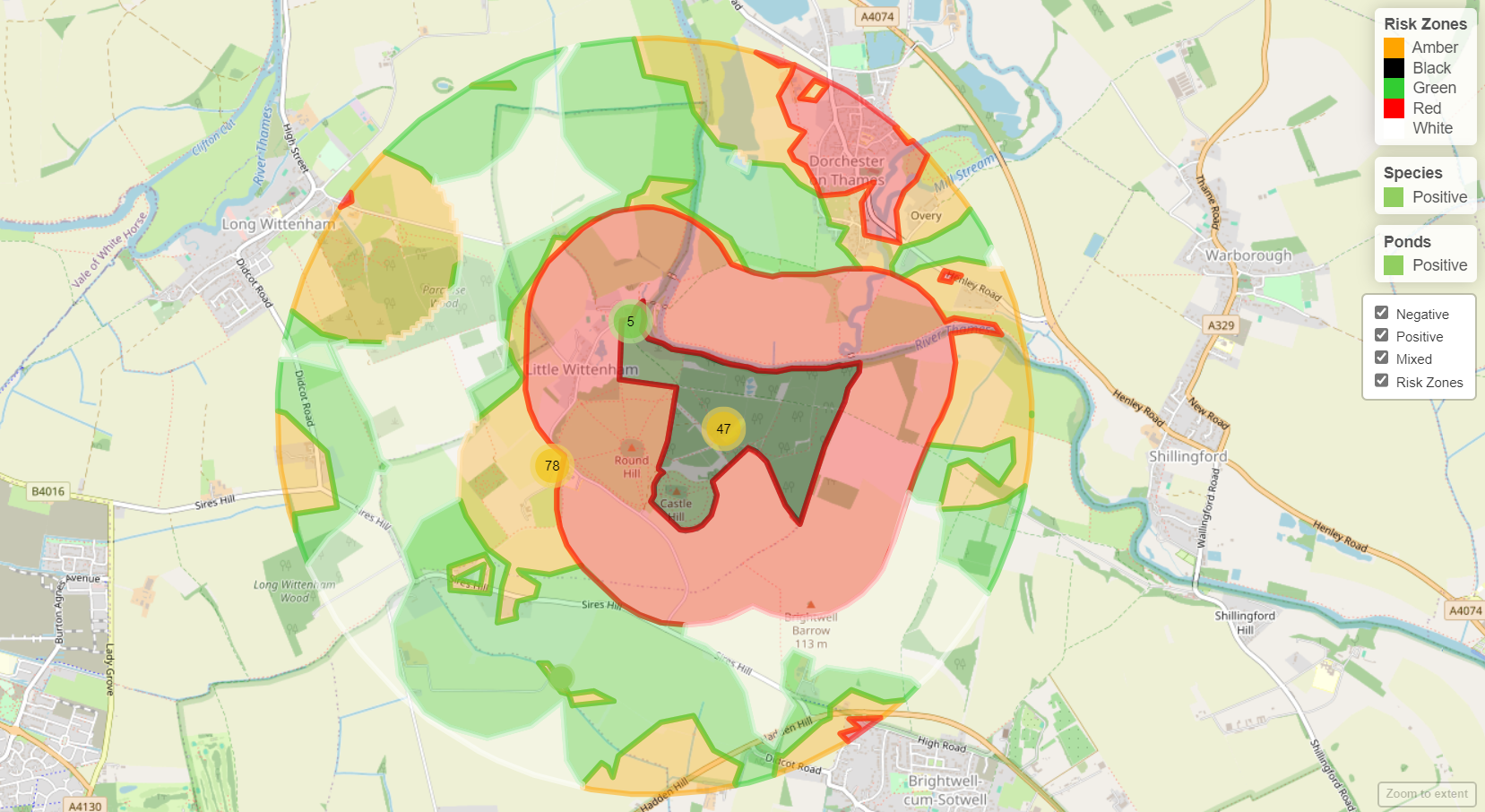
Great crested newt (GCN) package
Our experience of data analysis and presentation has produced the GCN package. The package supports ecological decision-making for this important species.
The GCN package includes data about:
- GCN occurrence (both positive and negative records)
- suitable habitats within the search area
- NatureSpace's GCN risk zones with results presented as a web map (view an example web map)
Swift package
A comprehensive summary table of records in both spreadsheet and Word format, detailing swift pairs, nests, breeding swifts, swift colonies, swift roosts, swifts in buildings, and swift bricks.
A "swift hotspot" map illustrating the distribution of swift records (as mentioned above) within the search area. Records are organised by location to indicate the number of swift records at each site.
Householder Search
The Householder search covers a 200-metre radius, summarising species affected by minor household developments. It includes records of House Martin, House Sparrow, Starling, Barn Swallow, Great Crested Newt, Badger, and their breeding, nesting, or roosting sites.
Data search results
Data search results are provided as:
- a PDF summary
- a PDF report
- an Excel spreadsheet of species
- either PDF maps of sites and habitats or GIS layer datasets (up to 5 km)
You should request a data licence rather than a data search:
- when a search area is greater than 10 km²
- for a 5 km buffer around a site
We will provide the data as GIS or Excel files.
Data coverage
Visit our species data page for our data coverage details.